Wednesday, April 25, 2012

The Future of Australia

Australia is in current location because of the formation and break-up of the supercontinent Pangaea around 220 million years ago. Continental drift and plate tectonics caused the break up of Pangaea.  In the short animation below, the continents move with the plate tectonics in the asthenosphere underneath the lithosphere. 
Photo Animation credit of Wikipedia: Pangaea
All three types of plate tectonics were responsible for the break-up of Pangaea; divergent tectonic movement separated Australia from Antarctica, creating a coastal landscape, while the Indian-Australian plate moved northward due to convergent tectonics and subducting under the Pacific plate. The northward movement melted the southern glacial climate into a dry, arid landscape as Australia moves towards the equator.
In the separation of Pangaea, the Indian-Australian plate did not converge with any other continents, meaning Australia formed as an island because the entire continent is located in the middle of the single large plate. Without any converging fault lines, Australia did not form any significant mountains making present-day Australia the flattest continent on the planet. 

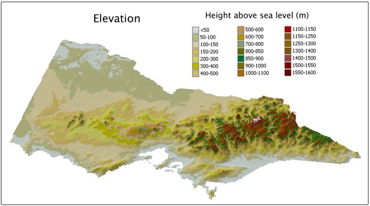
This topographic relief map of the state of Victoria, AU demostrates how minimal the elevation is.  The highest point above sea level is the tiny portion of the rust red color at about 1,100 metres or 3,600 feet.
Photo Credit: http://vro.dpi.vic.gov.au/dpi/vro/map_documents.nsf/pages/vic_elevation

Since landscapes develop over millions of years, the visibility of changes to the Southeastern Australian landscape in the next ten years would not be noticeable to the untrained human eye.  But the physical coastal landscape constantly changes due to the process of dissolution, also called chemical weathering.  The weathering process is influenced by the moon’s gravity that creates tides, causing waves to crash into the soft sandstone coastline of Southeastern Australia.  Over the next ten years, it is possible that some of the current "Twelve Apostles"/stacks will collapse because the continual process of fluvial erosion.  This is predictable because the current sea stacks are evidence of where the Australian coastline used to be, and has eroded to its current location.  The collapse of the sea stacks will occur as the wave cut notches at the base diminishes the strength due to the undercutting and eventually the top heavy stacks will collapse into the Southern Ocean.
The Apostle stack that collapsed in 2006 is incredibly close to the coastline.  As the coastline continues to erode, the Great Ocean Road which allows tourists to view the length and beauty of the Southeastern shore, will eventually erode into sea stacks, and collapse into the ocean below.
Photo Credit: http://www.theage.com.au/articles/2005/07/03/1120329326001.html


While the coast has frequent rainfall, the climate dramtically changes a few miles inland to desert. The extreme aridity of Australia's climate is significant because there is only one major river flowing through all of Southeastern Australia, called the Yarra River, with several tributaries that diverge throughout the region.  The development of human civilization is therefore relatively sparse and settlements are generally located along the tributary banks of the Yarra River.  Civilization in the next one hundred years  is unlikely to spread too much further inland into the arid climate.
Major human civilization is all located along the banks of the Yarra River in Southeastern Australia. Photo Credit: Wikipedia: Yarra River

The cyclical process of La Niña and El Niño that transitions about every seven years from seasonal rainfall to relatively dry, respectively, that led to the numerous deadly fires throughout the region in the early 21st century will likely continue for the next one hundred years, causing severe droughts and fires that threaten lives and property.  If sea temperatures rise, the strength of El Niño will increase the severity of the dryness and fire dangers.
In the next one thousand years, the Earth could begin a shift from its current interglacial period into a glacial period.  If that happens, as glaciers and polar ice caps refreeze, sea level will drop.  As a coastal region, Australia will be more affected  by changing sea levels. If the sea levels drop, the receding coastline would cause the current-day continental shelf to surface.
Alternately, if the sea levels rise, life will have to cope with the submersion of coastline and move further inland into the arid climates with the freshwater Yarra river deltas intermingling with the high salinity of the Pacific and Southern Oceans. 

Friday, April 6, 2012

BLOG # 3 - Climatology and Brushfires


Southern Australia is divided into two climate types: temperate on the coastal region and semi-arid/arid desert grassland region further inland.  In Köeppen’s climate classification system, the coastal region is a “Cfb” on the Pacific Ocean and a “Csa” on the Southern Ocean coastline. The capital C indicates that it is a Mesothermal Mild Mid-latitude climate, while the “fb” is a marine west coast with a humid and hot summer and the “sa” is a Mediterranean dry, hot summer.  Further inland Australia’s climate dramatically shifts to a “BSh” climate. The capital “B” indicates that it is a dry climate, while the “Sh” indicates that it is a subtropical steppe allowing the viewer to extrapolate that the grassland area is a hot semi-arid region. The image below illustrates the divide among the climate regions of southeastern Australia.
http://clasfaculty.ucdenver.edu/callen/1202/Climate/EarthTempClim/mapclimateQTVR.mov
The arid climate of New South Wales can be correlated to the Southern Oscillation of El Niño because the central Pacific currents rise in temperature about .5°C which decreases the strength of the Pacific trade winds, thus reducing the amount of rainfall that reaches land.  La Niña has the opposite effect to increase rainfall that reaches the mainland, but the fire danger is still of critical importance because Australia is a semi-arid climate.
Recorded rainfall in Australia one month prior to the Black Saturday fires
http://reg.bom.gov.au/climate/enso/lnlist/

Although El Niño can exacerbate the drought conditions of Australia, the fire danger consistently ranges from moderate to severe to catastrophic according to the Bureau of Meteorology. The lack of rainfall can be extremely dangerous and deadly for southern Australia. The arid climate can be so severe that brushfires erupt into massive uncontrollable fires across the entire southern region. 
Fires in Victoria, Australia throughout the last decade

These fires occur nearly every summer and the image above depicts the number and severity of fires throughout Victoria over the last decade. The Black Saturday fires were caused by an El Niño event and comprised of nearly 400 individually burning fires.  The fires lasted from February 7, 2009 and March 14, 2009 and were the deadliest fires recorded in recent history with 173 deaths and 414 people severely injured across the entire southeastern region of Australia.

Tuesday, February 14, 2012

BLOG # 1 - Newer Volcanic Providence of Victoria, Australia

Australia sits directly on top of the Indo-Australia plate, which is currently moving north at a rate of 7.5cm/year by subducting, or sinking, underneath the Pacific and Indo-Asian plates (Volcano World).
The black arrows indicate the Indian-Australian plate is moving north, and underneath the Pacific plate. While the opposing arrows at the bottom of the image indicate the divergence between the Antartica plate and the southern edge of the Indian-Australian plate.  The northern movement of the Indian-Australian plate is relevant to the volcanic development along the eastern coast of the Australian island.


Photo Credit: http://volcano.oregonstate.edu/vwdocs/volc_images/australia/volc_australia.html


 A hotspot is a stationary location where magma rises up from the mantle through weaker spots in the earth’s crust causing exterior volcanic activity.   Volcanologists have identified a solitary hotspot that created the Newer Volcanic Providence in Southeastern Australia. 


Photo Credit: http://en.wikipedia.org/wiki/East_Australia_hotspot
Text cropped into corner of image credited to: Julia Johns


The physical markings of plate movement are demonstrated by the linear development of volcanic regions from northern Australia, with the youngest volcanoes on the southern coast of Australia and even younger volcanoes on the island of Tasmania. The two images below demonstrate the northern movement of the Australian plate to create the linear volcanic development from north to south, due to the stationary hotspot as the continent travelled for millions of years over the hotspot.


As the plate moves over the hotspot of rising magma, a chain of volcanoes is formed


Photo Credit: http://en.wikipedia.org/wiki/File:Hotspot(geology)-1.svg


Mount Shank is the youngest volcano on the southern coast of Australia because it was the last volcano to erupt on the island around 5,000-7,500 years ago.  All the volcanoes along the Newer Volcanic Providence are considered to be dormant.
http://www.seismicity.see.uwa.edu.au/welcome/seismicity_in_australia/volcanoes_and_earthquakes_in_southeastern_australia


"Mount Schank's cinder cone-shaped landform is a rare South Australian example of volcanic activity in recent geological time" (DENR, Australia)


http://www.environment.sa.gov.au/Heritage/Heritage_places_and_areas/State_heritage_areas/Mount_Schank


In geological timeline, all of the volcanic and tectonic plate development described above happened relatively recently, but spans eons of human history.  Since the hotspot is no longer underneath Victoria, Australia, the threat of volcanic activity threatening urban life is non-existant. 
The final image of Mount Shank even depicts agricultural and irrigation development across the cone, which is protected geological/historical land under the Victorian providencial government Department of Environment and Natural Resources. 


It is still debatable whether the Newer Volcanic Providence should be considered "dormant" or "extinct" because there is no foreseeable threat to human life but scientists cannot prove without a doubt that the volcanic chain will never be active again.


Works Cited


Australia, D. o. (n.d.). Mount Schank State Heritage Area. Retrieved from http://www.environment.sa.gov.au/Heritage/Heritage_places_and_areas/State_heritage_areas/Mount_Schank

Volcano World. (n.d.). Retrieved from Oregon State Volcanology: http://volcano.oregonstate.edu/vwdocs/volc_images/australia/volc_australia.html


Saturday, February 11, 2012

Geography Comic

This is purely for amusement - and not intended to be part of the first blog assignment due this Tuesday 2/14/12.

Photobucket
photo credit: Bizarro. Dan Piraro.

According to www.marianatrench.com, the Mariana Trench measures at 11,033 meters or 36,201 feet.

Works Cited:

http://www.marianatrench.com/mariana_trench-oceanography.htm

Thursday, February 9, 2012

BLOG # 2 - Twelve Apostles

The southern coast of Australia is layers of limestone sedimentary rock which you can see as the lighter and darker layers in the first image below.  Sedimentary rocks contain joints at the different layers because each layer has different levels of hardness, allowing weathering forces to take advantage of the weaknesses of the rock.  These joints are responsible for the development of the Twelve Apostles along the Great Ocean Road in southern Australia.

Photo Credit: Janet Julia Kennedy

Ten to twenty-five million years ago, the coastline of Australia was where the stacks exist in the middle of the ocean, and has since eroded from the relentless power of the Southern Ocean waves crashing into the limestone. The erosion is a form of chemical weathering called dissolution which the rock is  completely dissolved by water. The distance between the stacks and the mainland is how far the ocean has eroded the coastline of Australia. With each subsequent wave, the softer rock is broken down and washed away into the Southern Ocean.   Over millions of years, the waves eroded the base enough to create caves, which you can see in the image below.
Photo Credit: Janet Julia Kennedy, photo of informational sign at Port Campbell National Park: tourist viewing area of the Twelve Apostles
Photo Credit: Dr. Casey Allen's February 16, 2012 class lecture, edited for accuracy
As the caves grow, the denser parts of the limestone are left behind creating arches between the pillars/stacks and the mainland. As the arches thin, they will ultimately collapse into the Ocean. When the arches collapse they leave behind only stacks of rock that are, as of today, about 450 feet tall.  


As discussed in the video, new stacks are constantly being formed because wave erosion is creating arches from the existing stacks.  You can see the waves breaking through one of the stacks about one minute into the video.  Eventually the arch in the picture below will collapse, creating two stacks out of one.  Over the next couple million years, all of the current stacks will collapse, but new ones will form out of the mainland.

Photo Credit: Janet Julia Kennedy
The Twelve Apostles have been an incredible tourist attraction for Victoria, Australia, making up a substantial portion of the $800 million tourist revenue that the Great Ocean Road provides annually.
http://articles.cnn.com/2005-07-04/world/australia.apostles_1_australian-state-stacks-sea?_s=PM:WORLD

http://www.vnc.qld.edu.au/enviro/landform/landf-su.htm


Friday, January 20, 2012

Introduction


This blog is created by Julia Johns for Dr. Casey Allen’s GEOG 1202, Sec. 001 Spring 2012 Physical Geography course.  For the duration of the semester, I will explore South-Eastern Australia, or specifically the states New South Wales and Victoria.  I have chosen to study Australia since my mom had the opportunity travel to Melbourne and Sydney in May 2009 and returned with remarkable photos and a promise to take me to visit if I get accepted to graduate school this fall.  I’m looking forward to doing this project to expand my knowledge from the cultural and political complexities of Australia to include the physical geography to wholly appreciate every aspect when I finally earn my mother-daughter trip to Australia after years of work to get there.